$349,900
Lot 5 Hwy 43, Kiln, MS 39556
 Land
Land  Built in ——
  18.45acre lot
 —— car garage
  $——/sqft
  Listed 6 months ago
Property Description
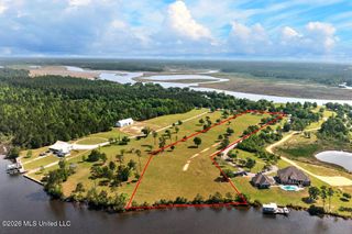
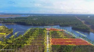
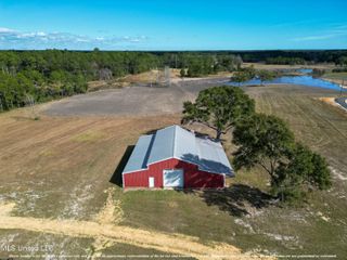
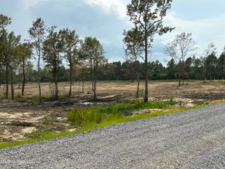
18 acres of cleared land. Ground has been leveled and de stumped and ready to build your dream barndominium and ready to create your own mini farm. Could also be used to build multiple homes. 15 minutes to the beach and 5 minutes to I-10. Centrally located in the Kiln area. Part of said parcel.
- Listing Status:
- Active
- Date Added:
- December 17, 2025
- Data Last Updated:
- June 23, 2026 at 2:40PM
- Listing Office:
- Ashman-Mollere Realty, Inc. : 228-467-5454
- Listing Agent:
- Anthony W Sheffield : 228-493-9695
- MLS ID:
- 4134129
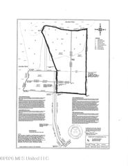
- Zoning: A PARCEL OF LAND SITUATED IN THE NORTHEAST 4 OF THE SOUTHWEST ¼ AND ALSO IN THE MARCOCK COUNT HESIS BENE MORE PARTICULARLY DESCRIBED AS FOLLOWS!5 WESTCOMMENCING AT A ½'' IRON ROD FOUND AT THE NORTHWEST CORNER OF THE NORTHWEST Y OF THE SOUTHEAST ¼ OF SECTION 13; THENCE ALONG THE NORTH LINE OF SAID NORTHWEST ¼ OF THE SOUTHEAST Y OF SECTION 13N89°49'12''E 1040.23' TO AN IRON PIPE FOUND ON THE WEST MARGIN OF HIGHWAY 43; THENCE ALONG SAID WEST MARGIN OF HIGHWAY 43525°36'50''E 146.09' TO THE POINT OF BEGINNING; THENCE FURTHER ALONG SAID WEST MARGIN OF HIGHWAY 43S25°36'50'E 27.40' TO A CONCRETE MONUMENT FOUND; THENCE FURTHER ALONG SAID WEST MARGIN OF HIGHWAY 43S19°42'36''E 100.73' TO A CONCRETE MONUMENT FOUND; THENCE FURTHER ALONG SAID WEST MARGIN OF HIGHWAY 43S25•30'58''E 617.10' TO A POINT; THENCE S89•49'12''W 1320.20' TO A POINT; THENCE N11°16'36''W 662.45' TO A POINT; THENCE N89°49'12''E 73.75' TO A POINT; THENCE ALONG A CURVE TO THE LEFTHAVING AN ARC LENGTH OF 104.80' AND A RADIUS OF 50.00'TO A POINT BEING N89•49'12''E 86.65'; THENCE N89°49'12''E 413.90' TO A POINT; THENCE ALONG A CURVE TO THE LEFTHAVING AN ARC LENGTH OF 107.40' AND A RADIUS OF 50.00'TO A POINT BEING N88'20'00''E 87.90; THENCE N86°48'35''E 476.70' TO THE POINT OF BEGINNING. SAID PARCEL CONTAINING 18.45 ACRES OF LAND MORE OR LESS076 -0-13-013.000
- Current Use: Agricultural
- Water: Public
- Sewer: Public Sewer
- Source: MLS United
This listing courtesy of Anthony W Sheffield , Ashman-Mollere Realty, Inc.
Monthly Payment
$Est. Payment
- Principal & Interest $
- Property Taxes $
- Home Insurance $
- VA Funding Fee $